
The ATSR Project
|

 |
STOP PRESS!
This ATSR-2 image from May 10th 2000 shows that the B15 iceberg has broken into at least two pieces
The latest sample ATSR-2 images (including the latest B15 iceberg images) can be seen at:
News Release
Biggest iceberg tracked from space
Tuesday 9 May 2000
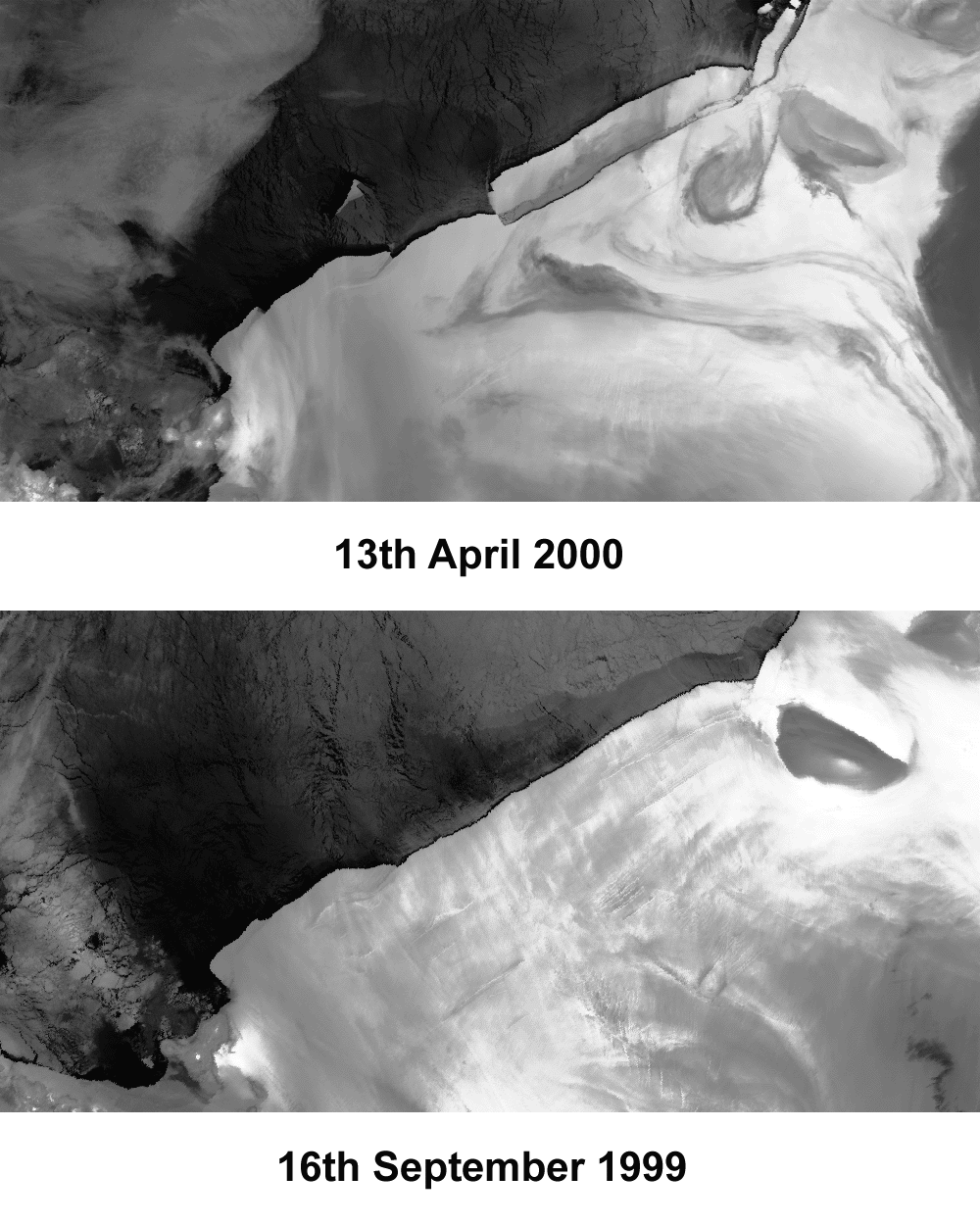
Space technology is being used to track what is one of the largest icebergs ever seen and certainly the largest in modern times, which recently broke off from the Ross Ice Shelf in the Antarctic. The images, taken by the ATSR-2 instrument on the ERS-2 European remote-sensing satellite, show the ice shelf as it was before the break-up (bottom, on 16 September 1999) and as it was three weeks ago (top, 13 April 2000).
The main iceberg, which has been named B15 by the US National Ice Centre, is about 300km from end to end (about the distance from London to York) and approximately 40km wide; it began to break off from the ice shelf in the last weeks of March 2000. In the top image, you can see a new iceberg breaking off to the East (right) of the main iceberg. This newly formed iceberg, named B17, although dwarfed by its big brother is in itself about 100km from end to end. To the west, a much smaller iceberg (approximately 40km long) has broken off the western tip of the largest iceberg and is making steady progress north-west.
"The calving of B15 is the consequence of a natural progression of events that occur in ice shelves, and is quite unrelated to 'Global warming' or 'Greenhouse' effects.", commented Neal Young from the Antarctic Co-operative Research Centre, Australian Antarctic Division - one of the users of ATSR data. "Previous to this calving, the northern edge of the Ross Ice shelf was the furthest north it has been this century."
ATSR-2 is an instrument that measures the temperature of the surface of the Earth extremely accurately. It is on board the ERS-2 satellite which is in polar orbit around the Earth. Both images of the iceberg are 12-micron thermal images. "The temperature of the water and the ice is obviously different, and this enables us to 'see' the ice shelf and the icebergs", explains Nigel Houghton of Space Science and Technology Department at Rutherford Appleton Laboratory, where data from the ATSR-2 instrument is processed. "It is great to be able to see these icebergs from satellites and we will be tracking this one with great interest. Once an iceberg is free from the ice shelf, it often moves fairly quickly. Tracking the Larsen iceberg in 1995 we saw it move about 6km a day once it had broken free, although they can drift at up to 30km a day", he added.
To see the images, click the following...
Other related internet links:
Background information on the iceberg by Neal Young at the Glaciology and Remote Sensing Department, Antarctic CRC and Australian Antarctic Division
http://www.antcrc.utas.edu.au/antcrc/news/b15_information.html
British National Space Centre, who co-ordinates space science research in the UK at
Natural Environment Research Council, who fund the ATSR project:
The ATSR instrument and ERS-2 satellite are operated by the European Space Agency. Further Information available from
British Antarctic Survey:
US National Ice Centre, who track and name large Antarctic icebergs:
Information about the ATSR projects, and other ATSR images, can be seen at:
Further information from:
Natalie Bealing, Press Officer, RAL, Tel: 01235 44 5484

Page last modified : Thursday, 06-Dec-07