
The ATSR Project
|

Vortex Streets
Main text by Ian Renfrew
A visible day-time image combining 1.6, 0.87 and 0.67 microns, showing the continued break-up of the B-15 Iceberg, with some interesting cloud formations.
This image was taken on the 17th September 2000.
|
The interesting cloud formations are known as 'cloud streets', and are generated by roll vortices in the boundary layer. These are convectively driven boundary-layer structures consisting of longitudinal vortices oriented approximately in the direction of the low-level wind, usually a a small angle. The roll vortices force patterns of convergence and divergence, which tend to coincide with cloud and non-cloud streets. The roll vortices are driven by a warming of the lower part of the boundary layer by the warm ocean surface and you can see that there is open water in fron of the ice shelf and icebergs. These polynyas (areas of persistent open water) open up under the action of strong offshore winds. There must be a lowe-level wind blowing off the ice shelf and off the ivebergs, which has firstly opened up the polynyas and secondly helped from the roll vortices. |
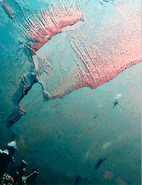
You see cloud streets frequently at mid to high latitudes during winter time, as cold air streams over a relatively warm ocean. What is unusual about this image is that the cloud street are formed over polynyas rather than open water. This has been seen before, but it is unusual and this image is particularly striking. The cloud streets have an incredibly well defined start point - at the ice shelf/iceberg edge, but the end points tend to tail off as the air moves further from the moisture source, the polynyas. For the cloud to start so soon after the ice shelf edge is unusual and normally there is around 10km before the clouds form - perhaps the air was almost at saturation?
Acknowledgements
Many thanks to Ian Renfrew

Page last modified : Thursday, 06-Dec-07